
Obama: Hurricane Irene likely to be ‘historic’
- The first rain bands hit the South and North Carolina coasts
- Significant power outages are likely, the homeland security secretary says
- “There is a very dangerous storm headed in our direction,” Mayor Bloomberg says
- Irene is expected to remain a hurricane as it slides up the East Coast to New England
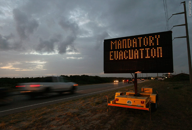
Kill Devil Hills, North Carolina (CNN) — Communities from the Carolinas to New England prepared Friday for what President Barack Obama wagered would be a “hurricane of historic proportions.”
As residents streamed from coastal North Carolina, where the storm was expected to strike first, the city of New York issued what Mayor Michael Bloomberg said was the city’s first-ever mandatory evacuation order, covering low-lying areas of all five of the city’s boroughs.
Authorities warned of widespread and prolonged power outages, flash flooding and storm surges that could flood low-lying communities and possibly inundate subway systems. The New York Metropolitan Transit Authority will shut down its system at noon Saturday.
New Jersey Transit also will shut down a noon, and the transit system in Philadelphia will halt service at 12:30 a.m. Authorities urged residents who need to leave to do so immediately.
“The sun is shining, but don’t be misled,” Bloomberg said. “There is a very dangerous storm headed in our direction.”
Gallery: Hurricane Irene sweeps along East Coast
Twitter Q&A for Hurricane Irene
Hurricane delays MLK Memorial dedication
Power company prepared for Irene?
Even guests in Atlantic City’s iconic casinos were being asked to leave immediately.
“All indications point to this being a historic hurricane,” President Barack Obama said in remarks from Martha’s Vineyard, Massachusetts, shortly before cutting short his vacation to return to Washington. The president was not in danger from the storm, his office said.
Irene was about 300 miles to south-southwest of Cape Hatteras, North Carolina, at 2 p.m.. ET Friday, according to the National Hurricane Center. The storm had weakened slightly, with top sustained winds down to 100 mph from 110 mph earlier in the day.
Still, Irene was expected to bring an ocean surge of up to 11 feet to coastal North Carolina, tearing away beaches and probably damaging homes, businesses and other structures before sliding up the East Coast all the way to New England, Hurricane Center Director Bill Read said.
Storm surges of 4 feet to 8 feet are possible in the Virginia Tidewater region, with 3- to 6-foot surges further north, Read said.
While the first rain bands hit the coastal areas of South and North Carolina on Friday afternoon, it will be either late Friday night or early Saturday before hurricane-force winds hit the area, he said.
North Carolina authorities reported evacuations were going smoothly. But not everyone was choosing to leave.
Charles Carawan said he planned to stay, along with his wife, son and $500,000 worth of crab stored at his seafood packaging business.
“I have nowhere else to go,” Carawan said.
Maryland Gov. Martin O’Malley said anyone who doesn’t leave is making a mistake.
U.S. military squares off with Irene
Why hurricane hunters fly into storms
N.C. man defies evacuation orders
Irene closes in on North Carolina
“Anybody that thinks that this is a normal hurricane and that they can just stick it out is being both selfish, stupid and also diverting essential public safety assets away from the task at hand, which is safeguarding lives and getting people out of the way,” O’Malley said. “It is the height of selfishness for people not to evacuate. One weekend of inconvenience staying with friends or family on higher ground is a small price to pay to protect life.”
Exactly where the storm will strike remained uncertain, but with hurricane-force winds extending 90 miles from the storm’s center and tropical storm-force winds as far out as 290 miles, the impacts will be widely felt, forecasters warned.
As of Friday morning, it appeared the storm’s center would make landfall between Cape Lookout and Hatteras in North Carolina, Read said.
“The timing is such that tonight into Saturday will be the worst for North Carolina and the Virginia Tidewater, Saturday into Sunday for the Delmarva (peninsula) and the eastern part of New Jersey, and then all day Sunday for New England,” Read said.
Governments and private agencies launched an immense effort to prepare for the storm.
The federal government began moving tons of supplies to military bases and other staging areas.
for more of this story:
http://www.cnn.com/2011/US/08/26/tropical.weather/index.html?hpt=hp_t1